Long-Term Monitoring Data: Murray-Darling Basin
Flow-MER is the Flow Monitoring, Evaluation and Research program of the Australian Government Commonwealth Environmental Water Holder (CEWH). It examines how ecosystems of the Murray-Darling Basin respond to management of water that is recovered for the environment under the Murray-Darling Basin Plan.
I have partnered with CSIRO and lead the Basin-scale data management group. We oversee the flow of environmental data into the Monitoring Data Management System (MDMS) and back out to scientists that assess how the Murray-Darling Basin is responding to the management of water for the environment. The data is gathered and evaluated by 7 regionally distributed "Area-scale projects" (expanding to 10 projects in 2024) that feed data up to a CSIRO led "Basin-scale" team. Here the data is aggregated and analysed to provide whole-of-Basin reporting to the Australian Government CEWH. For more information on Flow-MER visit the website.

Ecological and hydrological monitoring data collected under this government program are a free public asset available to everyone. The CEWH publish the data to data.gov.au under an Open Data policy in accordance with FAIR principles ensuring the data is Findable, Accessible, Interoperable and Reusable.
This article and the links below provide additional on-ramps to the data that improve "findability". Have at it.
 FISH
FISH
Fish Adult Catch
Electrofishing and fyke net fish catches collected by the Flow-MER program in the Murray-Darling Basin. Abundance and diversity of riverine fish populations are monitored annually at fixed sites within six Area-scale projects using a standardised sampling regime involving boat or backpack electrofishing and fine mesh fyke nets (referred to as Category 1 sampling). These methods target large-bodied and small-bodied fish species respectively. Fish are returned to the water after capture and measurement. These data are the catch data.  Access on data.gov.au Alternate link
Fish Length Weight
Length and weight measurements for individual fish collected as part of the Commonwealth Environmental Water Holder (CEWH) Flow-MER program in the Murray-Darling Basin. Abundance and diversity of riverine fish populations are monitored annually at fixed sites within six Selected Areas using a standardised sampling regime involving boat or backpack electrofishing and fine mesh fyke nets (referred to as Category 1 sampling). These methods target large-bodied and small-bodied fish species respectively. A sample of measured individuals (length and weight) were collected for otolith sectioning and age determination to construct age vs size relationships. Access on data.gov.au Alternate link
Fish Age
Age of individual fish collected as part of the Commonwealth Environmental Water Holder (CEWH) Flow-MER program in the Murray-Darling Basin. Abundance and diversity of riverine fish populations are monitored annually at fixed sites within six Selected Areas using a standardised sampling regime involving boat or backpack electrofishing and fine mesh fyke nets (referred to as Category 1 sampling). These methods target large-bodied and small-bodied fish species respectively. A sample of measured individuals (length and weight) were collected for otolith sectioning and age determination to construct age vs length and weight relationships. Access on data.gov.au Alternate link
Fish Larvae
Fish larvae counts from light traps and drift nets collected in the Murray-Darling Basin by the Flow-MER program. Spawning of both native and introduced species was measured by collecting eggs and fish larvae using drift nets and light traps during the known spawning period at five Selected Areas (Edward/Kolety –Wakool River System, Goulburn River, Lachlan River System, Lower Murray River, Murrumbidgee River). Bongo tow nets, rather than drift nets, were used to sample pelagic fish in the Lower Murray River due to very slow flow velocities. Access on data.gov.au Alternate link
 Waterbirds
Waterbird Breeding Colonies
Colonial waterbird breeding colonies monitored in two Selected Areas of the CEWH’s Flow-MER program (the Murrumbidgee river system and Lachlan river system). These are overall statistics of the colony size (nests/individuals) and start and end dates with estimated breeding success for colonies where detailed nest observations are conducted. Access on data.gov.au Alternate link
Waterbird Diversity
Waterbird species counts in three Selected Areas of the CEWH’s Flow-MER program (the Murrumbidgee River, Gwydir river system and Junction of the Warrego and Darling Rivers. Counts are recorded from a representative part of the wetland and the proportion sampled is recorded. Access on data.gov.au Alternate link
Waterbird Breeding Subsample
Waterbird breeding nest surveys conducted in two Selected Areas of the CEWH’s Flow-MER program (the Murrumbidgee river system and Lachlan river system). Nest, egg and chick counts are made in a representative part of the wetland to characterise the colony and to estimate colony breeding success. Access on data.gov.au Alternate link
 Vegetation
Vegetation Species Abundance
Ground storey vegetation species cover data (species x percent cover) collected as part of the Commonwealth Environmental Water Holder (CEWH) Flow-MER program in the Murray-Darling Basin. Access on data.gov.au Alternate link
Vegetation Community Structure
Plant community structure and observed inundation in vegetation plots collected as part of the Commonwealth Environmental Water Holder (CEWH) Flow-MER program in the Murray-Darling Basin. Access on data.gov.au Alternate link
Vegetation Recruitment
Counts of seedling recruitment in vegetation plots collected as part of the Commonwealth Environmental Water Holder (CEWH) Flow-MER program in the Murray-Darling Basin. Access on data.gov.au Alternate link
 Water Quality and Metabolism
Water Quality Measurements
Water quality parameters that are measured by field teams at various sampling points within the Murray-Darling Basin on discrete dates as part of the CEWH's Flow-MER program. Access on data.gov.au Alternate link
Metabolism Oxygen Logger data
Dissolved oxygen in the water column is a primary input into the calculation of metabolism and respiration (refer Metabolism BASE Model dataset). Data loggers are deployed at multiple locations in the rivers of each of the Flow-MER Area-scale project to measure continuously at 10 minute intervals:
- Light
- Water temperature
- Dissolve oxygen
- Atmospheric pressure
The data record aims to be continuous over the summer water management period, however there are breaks in the data record due to high water levels preventing data retrieval and equipment losses. There is generally at least one data logger deployed near locations where fish are also sampled. Access on data.gov.au Alternate link
Metabolism BASE Model Estimates
Volumetric estimates of organic carbon being created by photosynthesis or consumed by ecosystem respiration. Flow-MER deploys data loggers to record changes in dissolved oxygen, light and temperature over the course of 24 hours with continuous recording every 5 minutes. The data is analysed using the statistical model ‘BASEv2’ (BAyesian Single-station Estimation). The model (Grace et al. 2015) was updated during 2016 in accordance with methodological recommendations contained within Song et al. (2016). Flow-MER converts these BASE volumetric estimates (this data set) into reach-scale estimates with the appropriate hydraulic information (cross-sectional area) to estimate the amount of organic carbon being created by photosynthesis or consumed by ecosystem respiration in a nominal 1 kilometre (km) stream reach at the gauging site. Access on data.gov.au Alternate link
Lower Murray River salt and nutrient export (loads and concentrations)
Water quality parameters expressed as daily loads as the total export from the Murray-Darling Basin contained within all water sources (total combined natural flows plus managed environmental water). Data are collected to calibrate transport models by the Lower-Murray Selected Area for as part of the Commonwealth Environmental Water Holder's (CEWH) Flow-MER program. Total daily loads expressed in tonnes:
- Salinity (tonnes of salt)
- Phosphate (kilograms of phosphorus)
- Particulate Organic Phosphorus (kilograms of phosphorus)
- Ammonium (kilograms of nitrogen)
- Particulate Organic Nitrogen (kilograms of nitrogen)
- Dissolved Silica (kilograms of silicon)
- Chlorophyll a (kilograms)
Access on data.gov.au Alternate link
 Hydrology
Frequency of Commonwealth environmental water - wetland and floodplain inundation
Extent of surface water (outside of river channels) thought to contain Commonwealth environmental water either alone or in partnership with other water holders. Mapped as the annual frequency of inundation. Raster data set derived from Landsat and Sentinel-2 observations of water extent checked annually with water managers. Excludes natural flooding and inundation by other sources of environmental water where there was not a component of Commonwealth environmental water. Access on data.gov.au Alternate link
Frequency of Commonwealth environmental water - watercourses
Geofabric watercourse lines in the Murray-Darling Basin mapping the annual frequency of Commonwealth environmental water in each 12-month water accounting year (1st July to 30th June). River lines are extracted from the Australian Hydrological Geospatial Fabric (Geofabric) v3.2 SH_Network. Access on data.gov.au Alternate link
Daily Flows with CEW component
Daily river flows (ML/day) for a subset of river gauges throughout the Murray-Darling Basin with a modelled estimate of the contribution of Commonwealth environmental water. The evaluation of flow regimes is based on comparison of streamflow recorded at these gauges for the water year with streamflow that would have occurred in the absence of the Commonwealth water program. The Commonwealth environmental water contribution is estimated using a baseline modelling approach based on either point derivation, water accounting, and water planning information provided by CEWH, WaterNSW, GMW, and MDBA.
The data set includes a continuous sequence of data for 100 gauge stations, with 43 additional gauges added in 2024 (refer lineage change log).
Data for 2014 – 2017 also includes an estimate of what flows would have been in the absence of river regulation (Flow Category = PRE). The modelling for these values by the LTIM project was discontinued in 2017. Access on data.gov.au Alternate link
 Other Biodiversity
Frog Abundance
Frog diversity and abundance and tadpole counts are measured annually by the Flow-MER program in wetlands of the Murrumbidgee river system and Gwydir river system. An earlier contribution (2015) from the Lachlan River is also included. Access on data.gov.au Alternate link
Turtle Measurements
Turtles that are collected in traps and fyke nets are identified to species and individually measured (shell size) and weighed. Turtle sampling in Flow-MER is not comprehensive. Access on data.gov.au Alternate link
Microinvertebrates
Microinvertebrates are measured as part of the food-web monitoring of the Commonwealth Environmental Water Holder's (CEWH) Flow-MER program in wetlands and rivers of the MDB. Access on data.gov.au Alternate link
 Spatial Datasets
Flow-MER Murray-Darling Basin managed floodplain
This data set extends the MDBA published Murray-Darling Basin managed floodplain (https://data.gov.au/data/dataset/murray-darling-basin-managed-floodplain) to include all areas watered with Commonwealth environmental water 2014-2021. Areas that are added are mapped by polygons from the ANAE classification of the Murray-Darling Basin data set that were identified as receiving inundation by Commonwealth environmental water by the Commonwealth Environmental Water Holder’s (CEWH) Long Term Intervention Monitoring (LTIM) project (2014-2019) and the first two years of the Monitoring, Evaluation and Research (Flow-MER) program.
The MDBA published Murray-Darling Basin managed floodplain (https://data.gov.au/data/dataset/murray-darling-basin-managed-floodplain) is a spatial data set that estimates the extent of the Murray-Darling Basin that can be influenced by environmental water under the Basin Plan. It includes:
- actively managed areas that can receive environmental water via large headwater storages or via The Living Murray ‘environmental works’ sites on the River Murray floodplain
- passively managed areas that receive environmental water via flow rules in water resource plans or via natural events
- areas that may be inundated with high flows if key constraints are overcome
Access on data.gov.au Alternate link
CEWH Murray-Darling Basin valley boundaries
Spatial data set of valley boundaries in the Murray-Darling Basin used to support the Commonwealth Environmental Water Holder’s (CEWH) monitoring, evaluation and research activities. Modified from the Sustainable Rivers Audit (SRA) valleys to partition the Selected Areas used in the Long Term Intervention Monitoring (LTIM) project and Flow-MER program and to align with water accounting in the Basin. Access on data.gov.au Alternate link
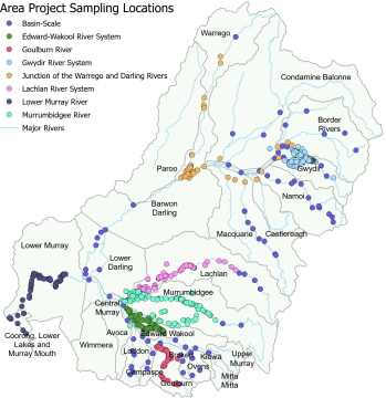
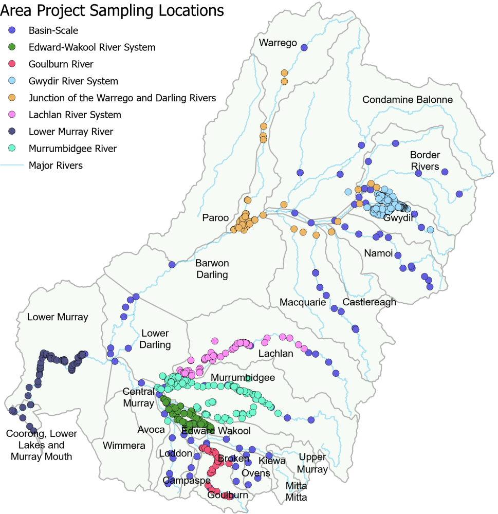
MDMS sample points (Flow-MER monitoring locations)
Location of sample Points configured in the Commonwealth Environmental Water Holder (CEWH) Monitoring Data Management System (MDMS). These are the points located on the map on this page. The MDMS stores monitoring data from the Long Term Intervention Monitoring (LTIM) project and CEWO Monitoring, Evaluation and Research (Flow-MER) program. The data set includes monitoring locations and Basin stream-flow gauging sites used in hydrology models (model nodes). Access on data.gov.au Alternate link