Seagrass mapping from Sentinel-2 at Ramsar sites
Seagrass is an important component of a number of Victoria's shallow water embayments that are listed by the Australian Government as wetlands of international importance:
- The Port Phillip (Western Shoreline) and Bellarine Peninsula Ramsar Site
- The Corner Inlet Ramsar Site
- The Gippsland Lakes Ramsar Site
Maximum likelihood classification of Sentinel-2 imagery using ESRI ArcGIS software allows us to map seagrass extent and monitor seasonal and inter-annual shifts in seagrass extent at these sites. There are now many more powerful deep learning and AI approaches available, but in practice, the relatively simple maximum likelihood classification has proven fit-for-purpose and very cost-effective.
Image classification uses the information in the many wavelength bands to classify the spectral signature of the reflectance from different surfaces. Water, vegetation, soils, and urban areas each reflect light in different ways and the unique reflectance fingerprint can be used to map their distribution in satellite imagery. Vegetation absorbs red light and reflects infrared enabling combinations of wavelengths to distinguish different vegetation types. In contrast, water absorbs infrared, so water will appear black to an infrared camera.
Sentinel-2 Imagery
The Sentinel-2 program of the European Space Agency (ESA) uses two satellites (Sentintel-2A launched June 2015 and 2B launched March 2017). Together they map the earth providing high spatial resolution imagery (10 m to 60 m pixels) with a combined return interval of 5 days. In Victoria, this typically provides at least one cloud-free view every 6 months suitable for mapping terrestrial vegetation or shallow water habitats.
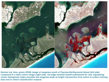
Visualising seagrass in Sentinel-2 imagery
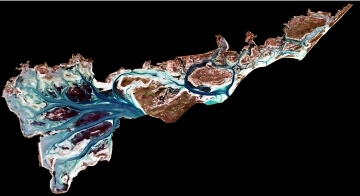
A trick to visualise seagrass in Sentinel-2 imagery is to substitute Band 5 ( 705nm red edge) in place of Band 4 (red). Whereas red light is absorbed by chlorophyll, Band 5 is a narrow band of visible and near infrared on the 'red edge' such that much of the light can not be absorbed by chlorophyll and is reflected by the leaf tissue. Applying a histogram stretch to give the red edge more prominence in the scene (Histogram Equalize in ESRI ArcGIS) makes seagrass "pop" in the imagery as bright red areas, and provides some discrimination between the seagrass beds, bare sediments and dark patches of accumulated debris and possibly beds of sponges and Pyura.
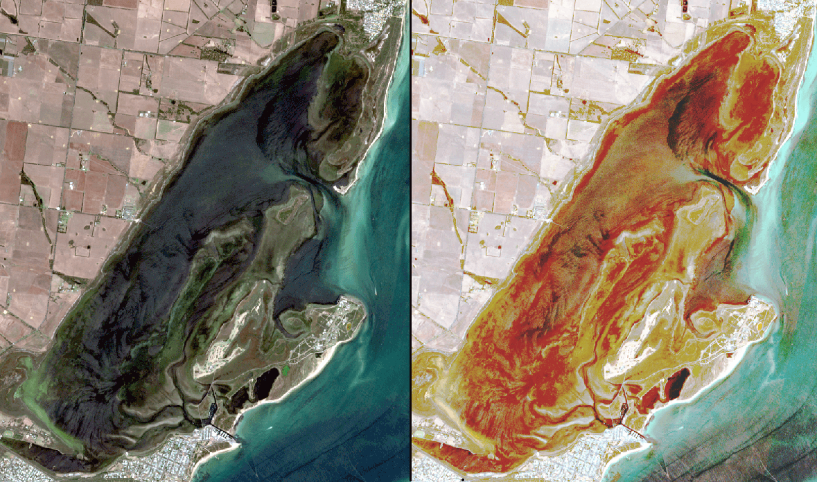
Swan Bay is a shallow coastal lagoon on the Bellarine Peninsula that has extensive seagrass beds and is part of the Port Phillip Bay (Western Shoreline) and Bellarine Peninsula Ramsar Site. Using the red-edge Sentinel-2 Band 5 and equalising the rgb histograms reveals the distribution of seagrass beds.
Getting the data ready for classification
Sentinel -2 images were pre-processed using the Sentinel Application Platform (SNAP):
- The third party sen2res plugin for SNAP provides “super-sampling” resolution enhancement for Sentinel-2 using the information contained in 10m bands to sharpen the lower spatial resolution red-edge (Band 5) from 20m to 10m (Brodu 2017).
- SNAP was also used to clip the Sentinel images to the Ramsar site boundary. Excluding all the areas you are not interested improves the performance of the classifier because there is less unwanted information to deal with.
- Land and water areas were masked using the sen2coral SNAP plugin LandCloudWhitecapMask processor using a reference value of 0.05 and masking all negative values. The classification of seagrass was constrained to shallow water areas only.
- The "water mask" was edited to exclude areas deeper the 4m bathymetry contour. Field studies have showed that light attenuation in these systems prevents seagrass growing beyond 4m depths.
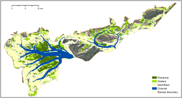
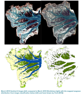
Mapping seagrass using maximum likelihood image classification
For mapping seagrass, the first five visible light and red-edge (Bands 1, 2, 3, 4, 5) were used. Water attenuates the infrared bands making them unsuitable for mapping seagrass. The red-edge 704nm (Sentinel Band 5) was included as it is a narrow band that is strongly reflected by chlorophyl and is useful for distinguishing seagrass from accumulated detritus and dark sediments
Areas that are known to be seagrass are identifed by reconciling visible patches of seagrass in the imagery with past field based seagrass mapping. Given the variable growth and distribution of seagrass (Zostera in particular), higher confidence in identifying patches as Zostera or Posidonia was achieved by intersecting past mapping to identify the areas that have been consistently mapped as the same species.
Data collected from the training areas provides the classifier with a spectral signature for seagrass and other features. The classifier then examines the spectral signature of each image pixel and assigns it to the class that it has the highest likelihood of belonging to.
Seagrass was classified using four categories:
- Dense seagrass
- sparse seagrass
- bare/sand
- deep water
For some projects we've also been able to classify to different seagrass species (Zostera or Posidonia).
For very large Ramsar sites like the Gippsland Lakes there are often differences in water colour and clarity in different areas of the lakes. Here we divided the lakes into a number of zones that stratify the differences in water colour and trained separate maximum likelihood classification models for each zone.
The mapping was an efficient and effective way to quantify the extent of seagrass that has been identified as critical to the ecological character of the Ramsar sites. We were able to evaluate the status of ecological character by comparing the mapped extent to the extents defined in the Limits of Acceptable Change (LAC) for each Site. The critical wetland extents were all within the acceptable limits.
Clients:
- East Gippsland Catchment Management Authority
- West Gippsland Catchment Management Authority
-
Department of Energy, Environment and Climate Action